With 1.5 to 3.0 inches of rain in the forecast for the next week for Iowa and South Dakota and .75 to 1.0 for much of Illinois, crop conditions could pick up into next week. This would reduce dryness issues in areas from Iowa, Illinois, northern Missouri, Indiana, and Ohio. Radar late yesterday showed rains dissipate as they move east and the 6-10 and 8-14 day forecasts has above normal temperatures returning to the northern tier of the belt including Iowa and Illinois, albeit with normal to above normal precipitation. The weekly conditions report showed 59% was rated good/excellent (G/EX) compared to 60% last week and 72% last year. The 10-year average for this time of year is 61%. The soybean ratings had seven states decline, eight states increase and three remain unchanged. Like corn ratings, Iowa’s (G/EX) soybean ratings went down 3% to 56% and the poor/very poor ratings going up 3%. Illinois G/EX went down 1% to 63% and Michigan’s went down 7% to 55% G/EX. North Dakota’s G/EX went up 7% to 44% and South Dakota’s went up 2% to 34%. Recent rains in the Dakota’s have stabilized the soybeans but G/EX ratings remain nearly half of last year’s ratings. Other states that saw improvements in the G/EX ratings: Indiana up 2% to 56%, Nebraska up 3% to 61% and Ohio up 2% to 55%.
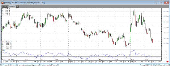
MARKET IDEAS: The condition report was not enough to offset the bearish weather outlook. Rains were moving into western Iowa this morning and the slow moving system may not move out until Thursday morning. If rains continue into this week, the trade will continue to grind lower for a test of 907. There is also some support at 923 ¾. If the weather forecast turns drier, there could be “air” above the market.
Nov ’17 Soybean Daily Chart


